Levee system battered by record rainfall from ‘atmospheric river’

- Share via
Reporting from Manteca, Calif. — As the latest major storm to saturate California got in its final licks Tuesday, the state deployed all the weapons in its flood-control arsenal — including farm tractors, pontoon boats and controlled releases from mountain reservoirs.
By nightfall, as the storm weakened over Northern California, it appeared that the region — so far — had successfully navigated its way through another “atmospheric river,” as meteorologists now call the intense, Pacific-born storm systems once known as the Pineapple Express.
To ease pressure on the Don Pedro Dam — a facility in Mother Lode Country that holds back water from the Tuolumne River — flows were being released through its spillway for the first time in nearly two decades. The released water is expected to reach San Joaquin County, more than 60 miles away, late Wednesday or early Thursday.
And as the snowpack melts in spring, the pressure on Northern California’s flood-control systems will remain. Particularly vulnerable is the labyrinth of earthen levees that protect cities and farmlands from runaway river water.
“We will have high waters on the levees for months,” said Charlie Hartford, an incident commander for levee maintenance agencies in and around San Joaquin County.
It was farmers to the rescue at first.
— Jenny Rich, spokeswoman for the San Joaquin County Office of Emergency Services
A full breach of a levee in that rural county, in the San Joaquin-Sacramento Delta, was narrowly avoided, in part because fast-thinking farmers arrived with tractors to plug a leak before it could expand.
“It was farmers to the rescue at first,” said Jenny Rich, a spokeswoman for the San Joaquin County Office of Emergency Services. About 500 residents were evacuated Monday night while the levee was repaired. They began returning home Tuesday.
Across Altamont Pass, in San Jose, Coyote Creek began to rise Sunday after rains filled Anderson Lake to capacity Saturday night.
A state Department of Water Resources spokeswoman said the outflow peaked Tuesday afternoon, flooding lanes of the Bayshore Freeway.
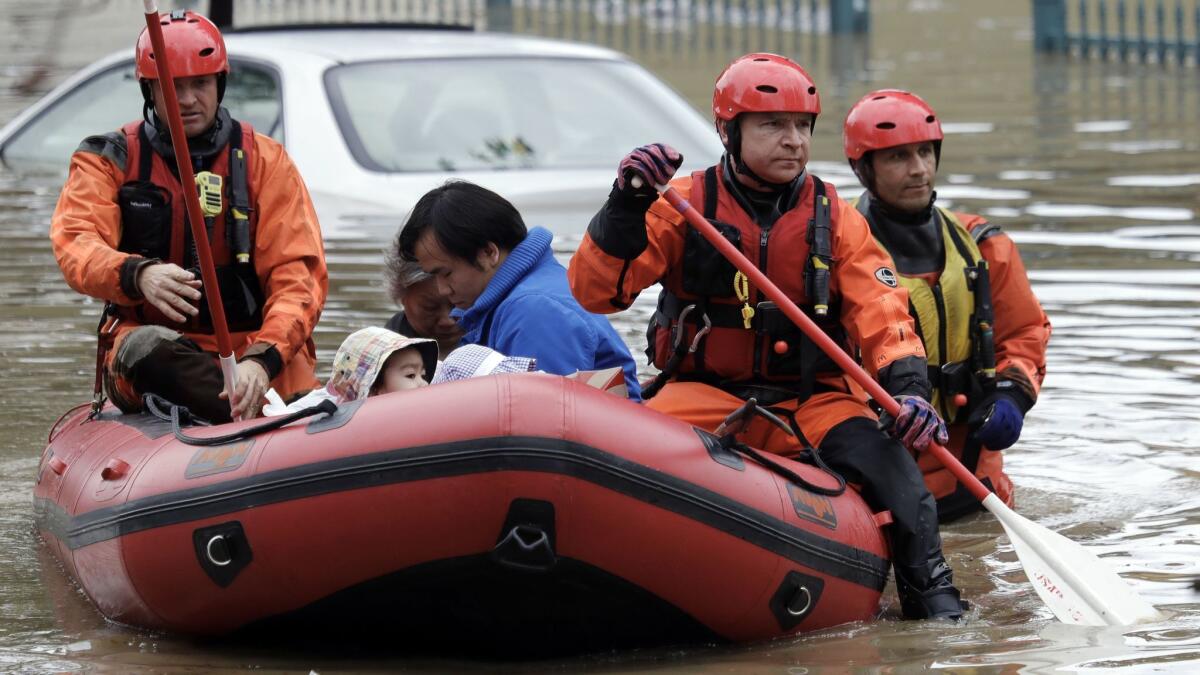
San Jose city officials declared a local emergency after streets became flooded as water levels rose along Coyote Creek. Firefighters navigated flooded streets in rafts, rescuing scores of residents trapped in their homes and in trees in the Rock Springs neighborhood.
Officials issued mandatory evacuations for 300 homes in the neighborhood, where water was waist-high in some streets, said city spokesman David Vossbrink. At least 40 people were evacuated to an overnight shelter.
“We haven’t really had anything quite like this before,” he said.
Those who walked through dirty floodwaters were hosed off and decontaminated, officials said.
Water levels were expected to start receding by midnight. After the water retreats, officials will go door-to-door to assess damage to homes, city buildings and other facilities.
Runoff from the rains also poured into the Shasta, Folsom and Oroville reservoirs Tuesday, but no problems were reported.
Acting Department of Water Resources Director Bill Croyle said at a news conference that the water flow into Lake Oroville peaked Tuesday morning, which may give engineers a chance to temporarily close the main spillway and get their clearest look yet at the 3,000-foot-long concrete structure’s damage.
Estimates have put repairs of the spillway at $100 million or more, but Croyle said it was too early to tell.
“Do we repair what we have? Do we replace what we have? Do we build the spillway somewhere else? All options are on the table,” said Croyle, who declined to provide a timetable for the spillway shutoff.
If you are protected by a rural levee or levees in the delta, you are not sleeping well.
— Jeffrey Mount, a senior fellow at the Public Policy Institute of California’s Water Policy Center
In San Joaquin County, while the breached-levee bullet was dodged, the emergency provided a warning of how much the Sacramento-San Joaquin Delta region relies on a system of several thousand levees to keep its residents safe from flooding in extremely wet years.
Rural stretches of San Joaquin County are at the greatest risk. Levees there are made up of dirt, rocks and sand and are designed to hold back water all the time, including during winter storms, said Jeffrey Mount, a senior fellow at the Public Policy Institute of California’s Water Policy Center. These levees require constant monitoring to ensure they don’t leak or break, he said.
“If you are protected by a rural levee or levees in the delta, you are not sleeping well,” Mount said.
Potential danger from failure in the state’s complex system of levees, which also protect the Sacramento region, has consistently been the subject of political debates. In 2006, state voters approved $4 billion in bonds to help repair levees in the aftermath of catastrophic failures of New Orleans’ levees during Hurricane Katrina. Then-Gov. Arnold Schwarzenegger made the issue central to his reelection campaign.
State and federal efforts since then have significantly improved the safety of Sacramento and surrounding environs, Mount said. Sacramento used to be more at risk of flooding due to levee breaches than any other metropolitan area in the country.
“Not even close anymore,” Mount said.
But Mount and other experts argue that substantially more needs to be spent – at least $20 billion – to secure the levee systemin the watershed regions of the Sacramento and San Joaquin rivers, especially with the threat of more dramatic weather patterns due to climate change.
Robert Bea, a professor emeritus in UC Berkeley’s civil engineering department, calls the state’s current efforts to repair levees in the San Joaquin Delta “patch and pray.”
“If the process of ‘patch and pray’ for whatever reason doesn’t work and you have a major breach in the levees,” he said, “the consequences of what happens next, as we have proven over and over, is very costly. Hence, you’re gambling. When people’s lives and a large amount of property are involved, I don’t like gambling.”
In the northern San Joaquin Valley, state and local officials said they were continuing to monitor the levees while Don Pedro and other reservoirs upstream continued to work to spill off the water generated by the wet winter.
“There’s a variety of sites we’re keeping our eyes on,” said Jon Ericson, chief of the hydrology and flood operations office at the state Department of Water Resources.
Staff writers Peter H. King and Veronica Rocha contributed to this report.
Twitter: @dillonliam
More to Read
Sign up for Essential California
The most important California stories and recommendations in your inbox every morning.
You may occasionally receive promotional content from the Los Angeles Times.


