- Share via
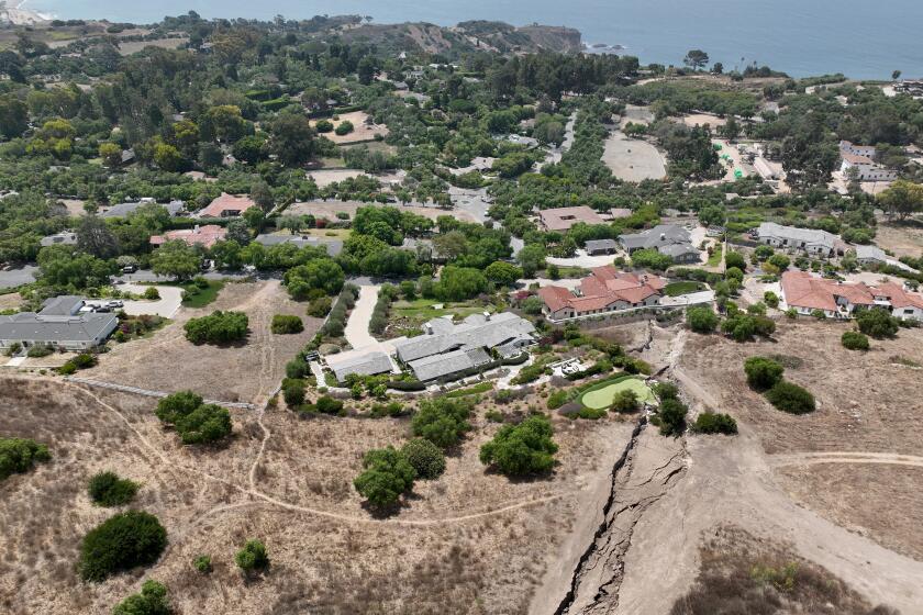
- James Bellis and his mother have a concerning crack on their Rolling Hills property, but without geological data from local officials, they feel in the dark about the extent of land movement in their area. It is a worry shared by many in Rolling Hills.
- ‘We just want to know what’s going on so we can make decisions for our property,’ Bellis said.
Standing on the far left corner of the three acres he owns in Rolling Hills, James Bellis, 40, points to a crack he’s been monitoring in the yard since August. It started from Quail Ridge Road, right above his property, and was about 240 feet long and an inch wide when he first noticed it — but now it runs more than 450 feet through the back of his property, and in one section is almost 16 inches wide.
He’s worried about what this land deformation could mean for the house on the lot, which he co-owns with his 80-year-old mother, Ann Bellis. She lives with her two Australian shepherds in the one-story home, which recently had its natural gas cut off because of land movement.
“We just want to know what’s going on so we can make decisions for our property,” said Bellis, who lives in Lake Arrowhead.
He has seen the devastation that has rippled through the neighborhoods in and around Portuguese Bend in Rancho Palos Verdes — just down the canyon — and wants to know what they’re up against.
Yet he’s still waiting on concrete answers.
In Rolling Hills, 35 homes are set to lose gas Monday, then 50 homes are expected to lose electricity by Wednesday.
So are more than 600 property owners in Rolling Hills. In contrast to the 1980s, when land movement in the Flying Triangle landslide area destroyed multiple homes there, the resident-run community association in charge of maintaining much of the gated city has only recently retained a geologist.
As a result, for at least a month, residents haven’t had a clear picture of how fast the land is moving near their homes.
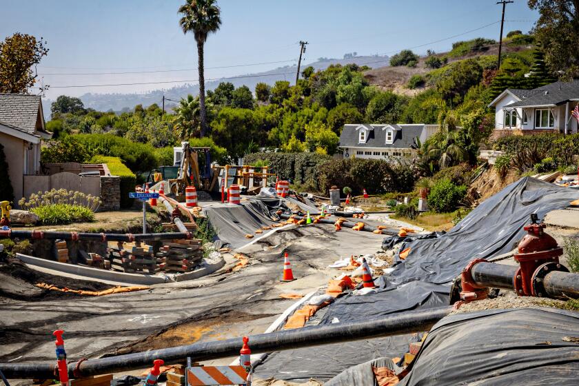
The fiercely private city of Rolling Hills was thrust into the very public, escalating emergency caused by increasing land movement in parts of the Palos Verdes Peninsula in mid-September, when Southern California Edison and Southern California Gas decided to cut service indefinitely to dozens of homes there — in addition to the almost 250 properties in nearby Rancho Palos Verdes that had been cut off weeks prior.

Ann Bellis was among those dealing with shutoffs, living without gas (and hot water) for about two weeks before her service was restored. Nevertheless, she told The Times she was lucky, as many of her neighbors across the street and in her community still lack both electricity and gas service.
“I loved to camp so I didn’t mind it. I just boiled water and all that,” she said.
In announcing the shutoffs, SoCalGas pointed to a recent water-main break and land movement, while Edison stated a “rapid increase in fissures” meant the company “cannot mitigate the public safety risk of downed poles and wires in the area.”
Rolling Hills Mayor Pro Tem Jeff Pieper acknowledged the fissures in the community but said: “It’s been like that for decades.” He was skeptical of the utility companies’ explanation for cutting services because neither shared their own geological reports; instead, they relied on analyzed data (from geological surveys, light detection and ranging, repair orders for damaged equipment and fire hazards) and “anecdotal observation,” Pieper said.
The city and most of the community “are not convinced the land is moving” at a rate that warranted utility shutoffs, James Bellis said, and he has yet to see any geological data that indicate otherwise.
On the city website, a page dedicated to land movement updates states that as of Oct. 1 there haven’t been any new updates, and moving forward, the city will provide new details “only when there is significant information to share.”

Unpredictable and accelerated land movement prompted power shutoffs in Rancho Palos Verdes. Faced with continued uncertainty residents struggle with solutions to stay in their homes.
Meanwhile, the Rancho Palos Verdes city geologist reported earlier this month that “creep movement” up to 0.7 inches per week has been recorded in Rolling Hills, specifically around Cinchring and Quail Ridge roads, affecting multiple properties — including Bellis’ home.
The big question — and concern — about this creeping in Rolling Hills is whether it might be linked to the devastating movement downhill around Palos Verdes Drive South, where land moved, on average, about 8 inches a week this last month, according to the geologist.

For the first time in months, that area saw movement decelerating, although the worst spots still were shifting 11 inches per week in August. There, at least two homes have been deemed unsafe to reenter, dozens of others have seen significant damage, the Wayfarers Chapel has been disassembled for safekeeping and several roads have become irreparable.
“Based on review of GPS monitoring data shared by Rolling Hills and recent field mapping, the upper limit of the new movement in Rolling Hills appears to cross upper Altamira Canyon,” the geologist wrote in his report. That Altamira Canyon refers to the deeper and larger underground landslide plane that officials recently discovered was driving the most dramatic movement in parts of Rancho Palos Verdes — and possibly into other nearby areas that hadn’t been under careful monitoring.
Mike Phipps, Rancho Palos Verdes’ contracted geologist, said at that city’s council meeting this month that he isn’t convinced that the Rolling Hills movement is directly related to the rest of the movement in the larger Altamira Canyon landslide, but it’s not yet clear.

“Those landslides may be separate,” Phipps said. He said he needs more data from land monitoring to understand how the different areas might be interacting.
Despite repeated requests from Rancho Palos Verdes, its city manager said this week that Rolling Hills officials still have not agreed to sit down for a meeting to collaborate on landslide issues between the two cities.
Previously Rolling Hills helped monitor land movement and passed that geological information along to residents, particularly in the 1980s, when land movement in the Flying Triangle landslide area was detected by Los Angeles County geologists. At the time, there was some disagreement among residents about whether the city should assist in tackling the movement that had destroyed several homes.
This time around, the city’s community association hired a geologist shortly before residents started losing utilities. By the September council meeting, though, the geologist had only 12 days of monitoring data.
Homes built on land with past landslide activity are on the market. Here’s how homebuyers can assess a property’s risk to land movement.
City officials told The Times that they know of three homeowners who hired their own geologists after noticing land movement on their properties.
“All residents are encouraged to monitor their properties for signs of land movement and report any fissures to the association and the city,” city staff said.
Once Bellis discovered the crack on his property was part of a larger fissure in the road, he said, he and his mother reported it to the city and the association.
The response from the association, he said, was: “Oh, we’ve got this, we’re working on it, don’t worry.”
But he is very worried.
Bellis and his mother have discussed what they would have to do in the event the fissures get worse and additional homes risk losing gas and electric service. They’ve talked about installing solar panels, which would require replacing the roof, or replacing the house’s two older gas furnaces with an electric heat pump, Bellis said. Either option would be costly.

Bellis’ grandparents purchased the land in the early 1950s and built their home. Ann Bellis said she grew up there, got married on the property and has hosted many other family marriages there too.
His family remembers when neighbors faced unimaginable devastation caused by the Flying Triangle landslide that became active in 1979. At the time, geologists said the land was shifting in two dramatically different directions, eventually destroying at least a dozen homes. Records show the area again saw issues from movement in the early 1990s.
Like other precarious hillsides in the Palos Verdes Peninsula, the Flying Triangle slide became an issue when the thin layers of bentonite clay sitting under tons of earth and rock got wet, becoming slippery, geologists at the time reported. Rolling Hills residents in years past said the movement slowed when weather was dry but accelerated after rains — a phenomenon that many Rancho Palos Verdes residents have been living with since back-to-back years of extreme rainfall caused unprecedented movement.
The Bellis’ property and the other properties affected by the recent utility shutoffs aren’t in the Flying Triangle area, but Bellis said he still found the region’s landslide history worrisome.
“For the future,” Bellis said, “my big concern is how to keep the water from making this crack any worse and eroding.”
More to Read
Sign up for Essential California
The most important California stories and recommendations in your inbox every morning.
You may occasionally receive promotional content from the Los Angeles Times.


