‘Calm before the storm’: California bracing for stream of late December rains

- Share via
Increased rainfall, with a growing chance for heavy precipitation over Christmas, is expected across much of California, beginning next week and lasting through the rest of December.
A southward shift in the jet stream is directing a string of storms toward the state — the first clear sign of the long-projected strong El Niño winter — with rain arriving in the Los Angeles area as early as Sunday.
“The jet stream is just the highway of storms,” said David Sweet, a National Weather Service meteorologist in Oxnard. “As that jet stream sags further and further south, we start seeing more frequent chances of rain.”
For the rest of this week, however, National Weather Service forecasters in Southern California characterized the next few days as “the literal calm before the storm.”
Through Saturday, the Southland is expected to remain dry and slightly warmer, with highs reaching into the 70s, until the first low pressure system moves down the West Coast.
That storm system will bring a chance of rain for much of California beginning Sunday, with the northern half of the state expecting precipitation slightly earlier, and Central and Southern California seeing most rainfall Monday through Wednesday, forecasts show. By Wednesday, another wet, low-pressure system could move in from the Gulf of Alaska. Sweet said that second storm is looking stronger and “could drop significant rain toward to the end of the week.”
But he cautioned that there’s “still a lot of doubt because that’s anywhere from one to two weeks out.”
“But some people are hopeful — if you like rain, that is,” Sweet said.

That rainfall pattern is likely to stick around until the end of the month — and probably longer, with forecasters predicting a “historically strong” El Niño, which tends to bring a wetter-than-average winter to the West Coast. Its effects are usually most pronounced in the second half of California’s traditional rainy season, between January and March, Sweet said.
“Each El Niño is different. ... Normally with an El Niño, especially a strong one, we tend to get a subtropical jet stream that moves across the state,” said Anthony Artusa, a meteorologist with the National Weather Service’s Climate Prediction Center. “This seems to be the pattern that is setting up.”
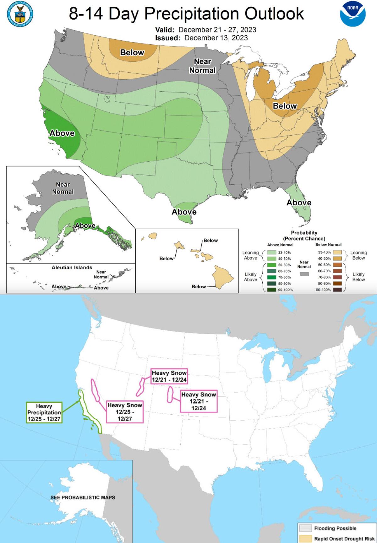
Long-range forecasters are predicting a moderate chance of heavy precipitation across coastal California south of San Francisco beginning Dec. 25 through Dec. 27, according to the latest hazards outlook from the Climate Prediction Center. That same forecast is also predicting a moderate chance for heavy snow across the Sierra Nevada at the same time.
“We’re expecting a wet Christmas,” Artusa said. “We’re expecting above normal precipitation for California. ... The better chances are down in the southern half of the state.”
He said coastal Californian south of San Francisco can expect up to 2 inches of rain from Dec. 22-28, with the possibility of some heavier bouts of rain locally. The Sierra could see up to 2 feet of a heavy snow, he said, and the storms are also expected to bring winds around 20 mph, with some gusts up to 40 mph.
“Around Christmas and in the days after that, assume there’s going to be some transportation issues,” Artusa said. “Be aware of potentially heavy rain in the lower elevations near the coasts, potential snow in the Sierra ... and the possibility of some stronger winds.”
Models are showing an “upcoming wet pattern across essentially all of [California] that will likely last at least two weeks,” Daniel Swain, a UCLA climatologist, wrote in a post on X, formerly Twitter. “Storms will start out very warm, with high snow levels, before becoming somewhat colder later in the sequence.”
He said this pattern aligns with what many weather experts predicted for El Niño: a wet winter following a drier autumn.
Swain said some forecasts “show heavy rainfall in some parts of [California] that could produce hydrologic concerns/flooding at times,” but noted that details remain uncertain this far out.
The latest precipitation outlooks from the national Climate Prediction Center continue to show an above-average chance for precipitation across much of South and Central California over the last two weeks of December. From Dec. 21-27, there is a significant chance for rainfall, while temperatures are expected to remain slightly above average. The three-month outlook through February is forecasting an above-average chance for rainfall statewide.
But the pattern of storms won’t start out too strong, with the first system bringing only light rain to the Southland through Wednesday.
“Sunday afternoon is when we expect our first very slight chance of rain,” Sweet said, hovering at around a 20% chance. He said no more than an quarter-inch of rain is expected in the L.A. area.
More to Read
Sign up for Essential California
The most important California stories and recommendations in your inbox every morning.
You may occasionally receive promotional content from the Los Angeles Times.


