Joaquin, still a Category 4, continues moving north
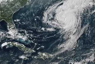
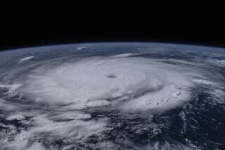
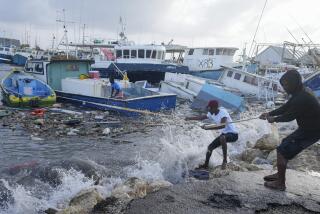
Hurricane Joaquin continued moving slowly toward the northwest on Friday as it battered the central Bahamas with 130 mph winds.tmpplchld At 8 a.m. Friday, the National Hurricane Center said Joaquin was starting an expected change of course that appeared increasingly likely to steer the dangerous Category 4 storm away from the Carolinas and the heavily populated New Jersey-New York area, which had been devastated by Superstorm Sandy. The latest track threatens Bermuda but would keep the massive storm well offshore of the East Coast as it slowly weakens to a Category 1 then tropical storm by midweek.tmpplchld But forecasters cautioned that the track could still shift over the next few days. And much of the coast could see impacts _ particularly from heavy rains that could produce widespread, serious flooding in some coastal states.tmpplchld “There is still uncertainty in how close Joaquin could come to Bermuda, extreme southeastern New England/Cape Cod, and Nova Scotia during the next several days, and interests in those areas should continue to monitor the progress of the hurricane,” forecasters said in the advisory.tmpplchld In the Bahamas, there were no immediate reports of injuries or deaths but the prolonged pounding was likely to increase damage. Reports were sketchy, but on Long Island _ at the edge of Joaquin’s powerful eyewall Thursday evening _ homes and streets were flooded from storm surge, and on Acklins Island just to the south, flooding was so bad that most of the nearly 600 residents couldn’t get out of their homes. Joaquin wasn’t expected to pull away from the Bahamas until later Friday evening.tmpplchld “They are under the gun,” said Capt. Stephen Russell, director of the Bahamas National Emergency Management Agency.tmpplchld The powerful storm was expected to generate a potentially deadly storm surge, increased from earlier advisories to five to 10 feet, that could unleash life-threatening flash floods, forecasters said. Near shore, the storm could kick up lethal waves. The wet storm is also expected to dump between 10 and 15 inches of rain over the region, with up to 20 inches possible in some areas.tmpplchld Photos posted on social media Thursday as Joaquin was still approaching showed several feet of water surrounding homes on Long Island, home to a few thousand people on the eastern edge of the central Bahamas.tmpplchld tmpplchld “It’s rough right now,” said Maxwell Burrows, 55, reached by phone from his home on Long Island. “The Internet is down. We don’t have any power and we are getting bad hurricane winds right now.”tmpplchld Burrows said even Superstorm Sandy in 2012, which caused damage across the island, wasn’t as bad. “What I’m scared of is that the storm is taking so long to go; it’s like it’s not moving,” he said.tmpplchld Joaquin was indeed crawling, moving at just 6 mph late Thursday, almost stalled as it waited for an approaching front that forecasters expected to sweep it north and away from the Bahamas.tmpplchld Cindy Bock who lived in the Salt Pond section of Long Island, said the rain pains were sporadic through late afternoon but she feared there would be a lot of damage if forecasters were right and Joaquin parked itself overhead for another day.tmpplchld “This is a farming and fishing community and it will impact it quite hard,” said Bock, an American retiree who moved to the island with her husband, Don, 17 years ago.tmpplchld Over in Rum Cay, resident Jacqueline Nottage said she didn’t start boarding up until Thursday morning when she heard Joaquin was strengthening. By 4:30 p.m. the island still had power and the eye had not yet passed over, Nottage said.tmpplchld “There isn’t much rain, but we can’t go outside because of the breeze,” she said. “The sea already started coming over the road and into some houses. We just got to give God thanks and hope for the best.”tmpplchld Hurricane force winds extended out 50 miles and tropical storm winds about 205 miles. The NHC said a 55 mph gust was reported at Guantanamo Bay, Cuba, Thursday.tmpplchld Though Joaquin’s proximity was unsettling for South Florida residents, none of the array of computer models used by forecasters showed the storm affecting the state. Even if Joaquin stays offshore, much of the East Coast could get hit with strong winds that could whip up coastal flooding, heavy surf and more rain. The mid-Atlantic could see significant beach erosion along with moderate coastal flooding, forecasters said. The Carolinas, already saturated from previous storms, also could see more rain and damaging flooding.tmpplchld Joaquin is the first major threat to the East Coast since Superstorm Sandy in 2012, which came ashore just north of Atlantic City and ultimately caused $75 billion in damage, making it the second costliest storm in U.S. history.tmpplchld ___tmpplchld (c)2015 Miami Heraldtmpplchld Visit Miami Herald at www.miamiherald.comtmpplchld Distributed by Tribune Content Agency, LLC.tmpplchld
More to Read
Sign up for Essential California
The most important California stories and recommendations in your inbox every morning.
You may occasionally receive promotional content from the Los Angeles Times.


