Capitol Journal: Before we can address the California drought, we need a geography lesson

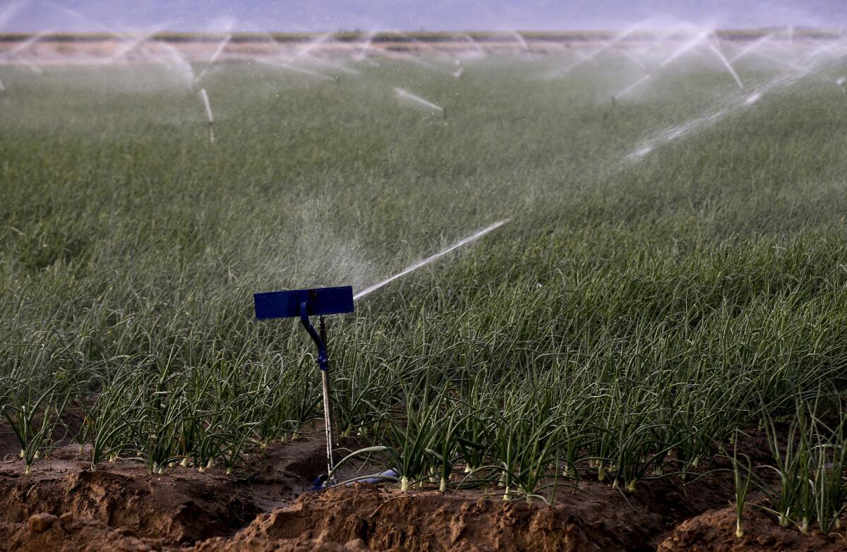
The Central Valley stretches 450 miles from Bakersfield north to Redding. Above, sprinklers work on the crops at Valpredo Farms south of Bakersfield in April.
Reporting from Sacramento — Many of us could use a refresher course in California geography as we debate how to manage the drought and prepare for an uncertain water future.
For starters, calling the hardest-hit farm region the Central Valley is much too simplistic.
Second, agriculture per se is not the issue — not the culprit guzzler. Rather, it’s the location of the agriculture, which gulps 80% of California’s developed water. Almonds, for example, make a lot of sense in some areas; a lot less in others.
Too often we try to wrap it all into convenient, simple packages — Central Valley and nut orchards — when more specificity is required to grasp the nub of the problem.
What part of the vast Central Valley? How dry is it and what’s being grown there?
Let’s begin with the basics. The Central Valley stretches 450 miles from Bakersfield north to Redding and is divided into significantly different hydrology regions that affect crop growing. Actually, they should affect it more, but farmers are free to plant whatever they want.
The long valley essentially is divided into two valleys — the San Joaquin and the Sacramento. It’s the much drier San Joaquin that usually is referred to casually as the Central Valley — and sometimes a looming dust bowl.
The San Joaquin Valley is drained by the San Joaquin River, which usually runs dry by summer downstream from around Fresno because so much water is diverted for agriculture. It resumes running again farther north when it’s replenished by tributaries.
The southernmost part of the San Joaquin Valley is the very dry Tulare Basin. There, Tulare Lake once was the largest freshwater lake west of the Mississippi but dried up a century ago because of agriculture diversions.
The Sacramento Valley is drained by the Sacramento River, which never runs dry. It has the second strongest water flow in the West, behind only the Columbia.
The San Joaquin and Sacramento rivers merge in the delta, east of San Francisco, where water is pumped south through federal and state aqueducts to valley farms and cities, including Los Angeles. What water’s left flows through San Francisco Bay to the sea, often carrying salmon for the coastal fishing industry.
The delta also is part of the Central Valley. But it has about as much in common with the San Joaquin as Long Beach does with Lancaster, although both are in L.A. County.
The importance in all this is that it’s much drier — and more water-gulping for crops — in the southern Central Valley than in the north.
Look how the average annual rainfall increases from south to north: 6.5 inches in Bakersfield, 11.5 in Fresno, 18.5 in Sacramento, 26.7 in Chico, 34.6 in Redding. That’s a 28-inch spread from very dry to very wet.
Temperatures don’t vary as dramatically, but it is hotter in the south than in the north. July high and low thermometer readings in Bakersfield are 97 and 71, in Sacramento 92 and 58, in Chico 94 and 61. That means less evaporation of irrigation water as you move north.
It all calculates to a greater need for irrigation in the south than in the north.
“You and I are going to drink more water in Bakersfield than in Colusa,” says Daniel Sumner, director of the Agricultural Issues Center at UC Davis. “Plants can store up more water in the north.”
Numbers have been compiled by Josue Medellin-Azuara, senior researcher at the UC Davis Center for Watershed Sciences. He figures it takes 4 acre-feet of irrigation water to grow an acre of almonds or pistachios in the Tulare Basin, where nut orchards have expanded the most in the last decade.
In the rest of the San Joaquin Valley, it requires 3.4 acre-feet. But in the Sacramento Valley, these nuts need only 2.4 acre-feet. That’s a difference of roughly one acre-foot, or nearly 326,000 gallons, enough to supply two households for a year.
There are 916,000 acres of almond and pistachio trees in the semi-arid San Joaquin, Medellin-Azuara says, but only 162,000 acres in the wetter Sacramento Valley.
The Sacramento used to be the main producer of these nuts, but when the federal and state water projects brought irrigation to the San Joaquin, the increasingly profitable and exported crops took off there.
Stone fruit — apricots, peaches, cherries — also require more irrigation in the south than in the north, 3.8 acre-feet compared with 2.8. Same with alfalfa, nearly 5 acre-feet contrasted with 4.
There’s also the problem in the south of over-pumping aquifers. In parts of the San Joaquin, the groundwater table has plunged 150 feet in the last 15 years and the land itself is sinking a foot a year.
Not so in the Sacramento Valley. “It’s in really good shape,” says Jeffrey Mount, a senior fellow at the Public Policy Institute of California and former director of the UC Davis watershed center. “When it rains again, that valley will recover much more quickly.”
In past columns, I have suggested that the state consider regulating crops based on their water demands and location. Gov. Jerry Brown flatly rejects that notion.
“You’re not the only person saying that,” Mount told me. “But it’s not said in polite company.”
The regulating will happen indirectly anyway within the next generation, he says, when new groundwater controls are implemented.
That can’t happen soon enough.
Twitter: @LATimesSkelton
More to Read
Sign up for Essential California
The most important California stories and recommendations in your inbox every morning.
You may occasionally receive promotional content from the Los Angeles Times.


