Salt marshes will vanish in less than a century if seas keep rising and California keeps building, study finds

On one side, thereâs the rising ocean. On the other, rising buildings.
Squeezed between the two are Californiaâs salt marshes â a unique ecosystem filled with pickleweed and cordgrass, shorebirds and many endangered species.
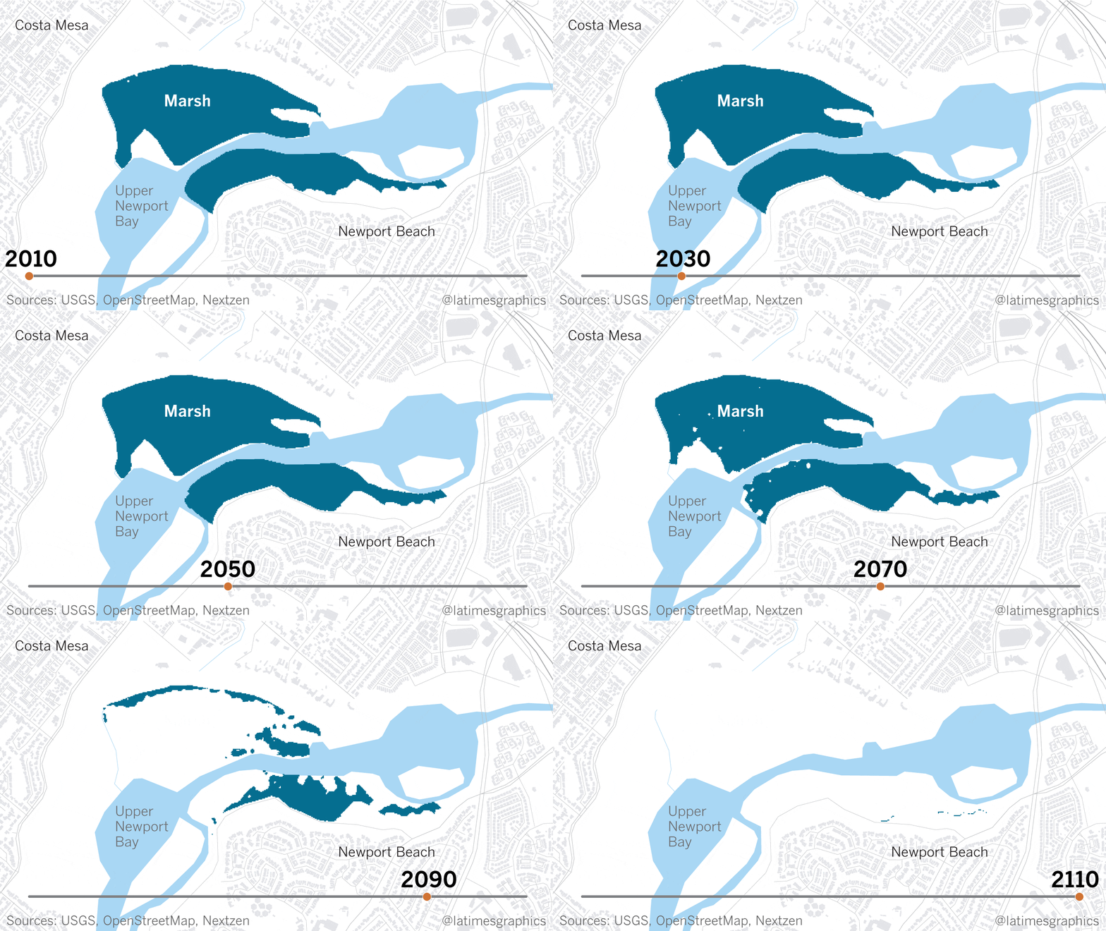
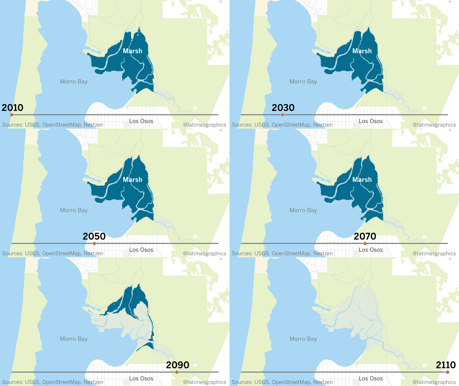
Coastal wetlands such as Bolinas Lagoon in Marin County, the marshes along Morro Bay and the ecological preserve in Newport Beach can purify the air, cleanse urban runoff before it flows into the sea and reduce flooding by absorbing storm surges like a sponge.
But thereâs little room left for this ecosystem along the changing Pacific Coast, as the sea continues to rise and Californians continue to develop the shore. Southern California today has already lost three-quarters of its salt marshes.
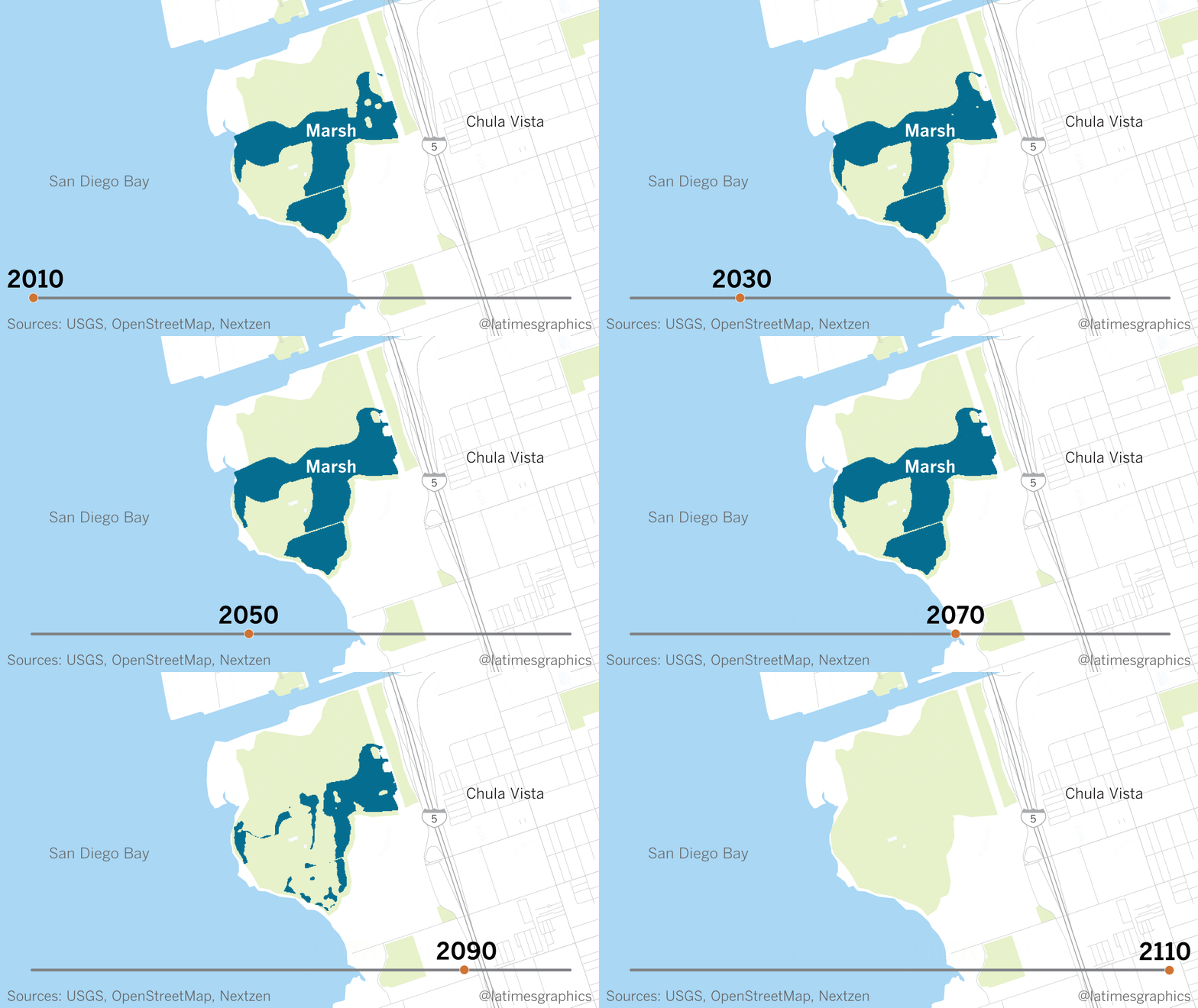
The rest could be gone within 100 years. Salt marshes in California and Oregon could disappear entirely by 2110, according to a new study by a team of scientists led by the U.S. Geological Survey. Only a few might survive in Washington. The research quantifies for the first time the fate of this entire ecosystem on the West Coast, based on current projections of sea level rise.
âWeâre essentially drowning the marshes,â said Glen MacDonald, a UCLA professor of geography and one of the authors of the study. âIf we stay on the same carbon pathway that we are on now, and we take a look at conservative estimates of sea level rise, we would see California vegetated salt marshes we know today, Oregon vegetated salt marshes we know today, 100% gone by the first decade of the 22nd century.â

The study, published Wednesday in Science Advances, examines 14 major estuaries along the West Coast, from the marshes of Port Susan Bay in northern Washington down to the Tijuana River Estuary.
Marsh by marsh, over the course of many years, scientists measured elevation, tidal flooding, the distribution of vegetation and rates of sedimentation. Using sea level projections by the National Research Council, they designed a sophisticated model to project how each marsh would fare. By even the most conservative measures, the damage was significant â especially in California.
Coastal marshes naturally adapt to sea level rise by migrating inland through a process called transgression. But by building the Pacific Coast Highway and developing up to the edge of basically every marsh, Californians have drawn a line in the sand.
âThink about Seal Beach, think about Carpinteria,â MacDonald said. âYou have expensive housing, you have commercial developments, you have our major coastal highways, the railroad, basically hemming in those marshes.â
The building of dams, channelizing rivers and paving roads have also cut off the natural amount of sediment that flow through these marshes and into the ocean, which would add the vertical height these marshes need to fight sea level rise.
This coastal squeeze is also eroding beaches. A USGS study last spring projected that up to two-thirds of Southern Californiaâs beaches could disappear by 2100 because of similar pressures from sea level rise and human interruptions to sediment flow.

Californiaâs marshes are already at a disadvantage compared to the East Coast and Gulf Coast, researchers noted, because of the steep cliffs along much of the coastline.
âNaturally, even without the people, thereâs limited opportunities for the marshes to adjust by moving inland,â said Richard Ambrose of UCLAâs Institute of the Environment and Sustainability, another author of the study. âBut even in places like Newport or Morro Bay, where there might be places naturally for them to move, weâve got the roads and weâve got buildings.⦠Adding humans on top of our natural coastline gives these marshes really nowhere to go.â
Beyond losing the hundreds of species that depend on this unique ecosystem, Ambrose said, the disappearance of these marshes would have a devastating impact on flood protection.
When thereâs this buffer of vegetation between land and sea, a storm surge cannot build up as much, he said. During Hurricane Katrina, for example, there was significant flooding in areas that once had marshes.
âLouisiana lost miles and miles and miles of wetland, and lost it for two main reasons: One is they channelized the Mississippi River,â Ambrose said. âThe other is all the oil and gas development â they dug a bunch of canals, which cut up the wetlands and made it easier for the wetlands to drown.â
USGS research ecologist Karen Thorne, the studyâs lead author, said the new research provides a modeling tool and a more concrete time-frame for policymakers on what must be done to conserve these marshes.
One option, which Thorne and others are studying, involves adding thin layers of sediment to a salt marsh plain to increase its elevation. But this approach is expensive and must be repeated to keep pace with sea level rise.
Another option, albeit less popular, would be for officials to strategically acquire property along the coast and keep it open for marshes to migrate inland. In the northern San Francisco Bay, for example, farmers have been retiring their lands to Sonoma Land Trust and fish and wildlife agencies. In 2015, a levee at Sears Point Ranch was breached to allow salt water to fill a 1,000-acre tidal marsh basin for the first time in more than a century.
âAre there other places where we can say, âYeah, we have some development here, but the cost of protecting it is going to be so high, whereas saving the marsh is compensation for the loss of that developed landscape?ââ MacDonald said.
MacDonald often thinks back to his first day of field research, in the Tijuana River Estuary, one of Southern Californiaâs last salt marshes. He marveled at the vast landscape, the undercurrent of life and the majestic shorebirds taking flight.
âYou really absorb just the beauty of these marshes and their importance â and then to realize, we could be among the last generations in California to see these ecosystems,â he said. âItâs unbelievably sobering.â
Interested in coastal issues? Follow @RosannaXia on Twitter.
More to Read
Sign up for Essential California
The most important California stories and recommendations in your inbox every morning.
You may occasionally receive promotional content from the Los Angeles Times.


