Southland developers learn to coexist with quake faults

Over the last 20 years, the plateau atop Signal Hill has been transformed from a gritty industrial zone into an upscale neighborhood of homes, parks and hiking trails.
Where hundreds of oil wells once stood, joggers and photographers navigate popular walkways and trails that meander around gated communities with dramatic views of the Pacific Ocean and the L.A. Basin.
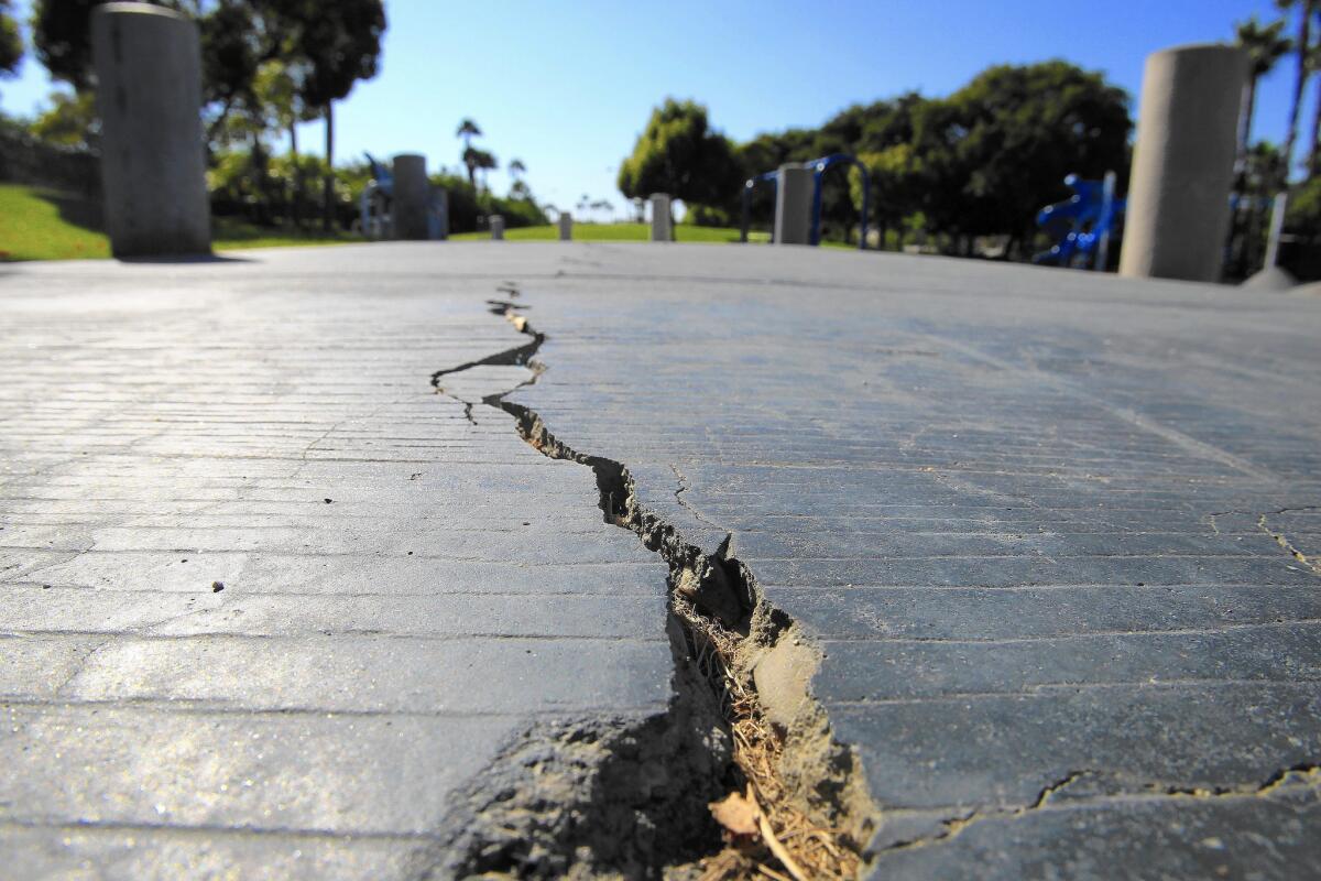
The layout of Signal Hill was not dictated simply by aesthetics. The city and developers created this landscaping to protect residents from a danger hidden just below the surface: the Newport-Inglewood earthquake fault.
The fault, responsible for one of the most destructive earthquakes in Southern California history, snakes through the hill north of the Long Beach Harbor. In accordance with state law, homes were carefully built around the fault, and parks and trails buffered areas where the ground could split in two.
As California this year embarks on a major campaign to better identify earthquake faults across the state, Signal Hill and other communities along the Newport-Inglewood fault offer lessons on how to allow for new development.
California lawmakers this year agreed to spend millions to speed up the mapping of faults, after stalling such work for nearly two decades. The move means that more parts of California will be subject to the stateâs strict earthquake law, which generally prohibits construction on top of active faults and requires developers to conduct extensive underground studies to pinpoint where the faults are.
The Newport-Inglewood fault was one of the first to be covered by the law, in the 1970s. The fault is about 46 miles long and runs from the Culver City area through Long Beach and into Huntington Beach before it heads offshore.
The Times surveyed newer developments along the fault and found that, to a meticulous degree, cities have been following the law. Large swaths of land along the fault have been transformed into new homes and businesses, but planners have managed to find ways to keep them a safe distance away, according to documents and interviews.
Near the faultâs northern terminus in Inglewood, a long, winding road cuts diagonally across a development that brought 374 new homes to the city in 2005. The development was considered a milestone because it was the first new housing in the city in more than 20 years.
The road, Renaissance Way, was designed to follow the path of the Newport-Inglewood fault. Tennis courts, parking lots, a pool and a barbecue area were built on and around the fault.
Developers went to great lengths to keep homes as far from the fault as possible. Geologists did seismic studies in 1986 and 2002 and dug more than seven trenches to pinpoint the faultâs location. They were unable to find the fault where the state said it could be.
They ended up using an old oil well study that had possibly found the fault. They changed their designs from a straightforward grid layout to a plan that built the houses around the wide curving road. Instead of having the gated entrance in the middle of the block, they moved it to the eastern corner of the development to help keep structures away from the fault.
âIt just takes creativity from architects and engineers to design around the issue to make sure itâs safe,â said Howard Press, president of Watt Communities, the main developer. âYou just donât put someoneâs bedroom on top of a fault. Thereâs a legal issue, but also a moral issue there. Itâs just something we werenât going to do.â
About a mile away, on Market Street near La Brea Avenue, an old warehouse sits on a small lot that developers for years have tried to turn into apartment buildings.
A preliminary underground study showed that the fault cut across the tiny lot in a way that would make it impossible to build apartments while avoiding the fault.
âThe fault report was never even finished,â said John Jones, a plan checker in Inglewoodâs building division. âThey did some trenching, found faulting, and there was no point going any further.â
Similar precautions were taken at the southern end of the fault, in Huntington Beach.
A long linear park stretches along the fault and through two major gated communities. Visitors and residents know the grassy 6.6 acres as Discovery Well Park, where families spend afternoons at the picnic tables and kids play on the basketball courts and the beach-themed playground.
Officials knew the fault would be an issue when they began drawing up plans that would bring thousands of new residents to the city. They discovered the Newport-Inglewood fault was underneath the northern portion of the Seacliff Village shopping center, built in the 1970s before the fault zoning law went into effect.
Developers demolished the center and rebuilt it. Now only the parking lot is directly on top of the fault.
Signal Hill was formulating its hilltop development around the same time.
City officials ordered a preliminary earthquake study upfront, as well as detailed fault studies for each phase of the development.
The faultâs location forced the developer to reduce the number of homes from 132 to 110. Roads were rerouted and a scenic hiking trail was designed into the plans to keep all the buildings a safe distance from the fault, according to documents and interviews.
The developer, Bob Comstock, said it came down to being upfront about the fault and disclosing how exactly it was incorporated into the project.
The development was a financial success, and all of the homes were sold by 2002. In fact, having trails and public parks meld right into gated communities has become âa very Signal Hill thing,â said Scott Charney, the cityâs community development director.
Now, the meandering trails are a part of the cityâs identity, Charney said, and another developer has sought to design them into a housing project that isnât even in the fault zone.
âA lot of the time, there are ways that you make better projects out of it,â Charney said. âI donât think this wouldâve happened without the faults.â
The Newport-Inglewood fault has received more attention from government officials than some lesser-known faults that crisscross the region in part because of the catastrophic 1933 Long Beach earthquake.
It was the first destructive quake in modern Southern California, killing 120 people, and prompted some of the stateâs first seismic building regulations. After the state passed the Alquist-Priolo Earthquake Fault Zoning Act in 1972, the fault was one of the first to be mapped. The rules covered new construction, but existing buildings were grandfathered in.
Mapping the fault was contentious at the time, recalls state geologist John Parrish. There was not a lot of underground trenching or useful soil samples in the area for scientists to work with, he said.
âThe cities of Long Beach and Inglewood and so forth were not very happy that we were putting the zone through there,â Parrish said.
Over the decades, the extensive underground studies required by the law have provided valuable scientific information on the Newport-Inglewood fault, Parrish said.
But implementation of the law has lagged in other parts of the state. Four decades later, about 2,000 miles of faults still need to be zoned â in places such as Los Angelesâ Westside, Orange County, Lake Tahoe, San Diego and the San Francisco Bay Area.
After The Times last year reported on the mapping delays, Gov. Jerry Brown signed legislation to renew funding and allocate more than $1 million a year to complete the remaining zones in the state. The funding will be financed by increased building permit fees.
The budget boost has allowed the California Geological Survey to begin mapping the Santa Monica fault, which curves through the Westside and the city of Santa Monica. The state in January released a draft map of the Hollywood fault zone and is expected to finalize it next month.
More to Read
Sign up for Essential California
The most important California stories and recommendations in your inbox every morning.
You may occasionally receive promotional content from the Los Angeles Times.


