Hurricane Hilary could bring ‘very heavy’ rains, winds, surf to California. ‘Really an unusual event’

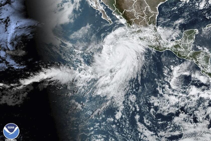
A storm brewing off Mexico’s Pacific coast and threatening Southern California and the southwestern U.S. was upgraded Thursday morning to hurricane strength.
Forecasters warn that it’s still too soon to confirm when — or if — Hurricane Hilary might make landfall, and how strong the system could become. But current projections show it could reach the Baja California peninsula by late Sunday, potentially bringing significant rain, rough surf and dangerous winds.
Hurricane Hilary is headed toward San Diego and L.A., with about a 50-50 chance tropical storm-force winds hit SoCal. What to know and how to stay safe.
“There’s a lot of uncertainty with the storm track and the intensity of the storm, but we will likely see some impacts,” said Eric Boldt, the warning coordination meteorologist with the National Weather Service in Oxnard. “We have to be prepared for the potential for very heavy rain, very strong winds, storm surge, large waves … This is a potentially high-impact event.”
It’s still too early to predict the likelihood that a tropical storm-strength system touches down in southwestern California, something the region hasn’t seen in more than 80 years, according to the National Weather Service.
It’s “really an unusual event overall,” Boldt said.
The last such storm — nicknamed El Cordonazo or The Lash of St. Francis — hit Long Beach in September 1939, drenching the region and knocking out power. Almost four dozen people died and about the same number were reported lost at sea, according to archival coverage from The Times and the San Diego Union-Tribune.
Thursday morning updates showed the hurricane’s track moving slightly more east than prior paths, with projections showing the system making landfall as a tropical storm in the Baja California Peninsula — but timing and strength remain the main uncertainty, according to National Weather Service officials.
Although Hurricane Hilary may not be as strong when it reaches California, it is still expected to drop a considerable amount of rain on the region.
No matter Hilary’s final track or intensity, Boldt warned of dangerous conditions in the Southland’s coastal waters, and said that “almost any location” across southwest California should expect up to 2 inches of rain by the end of this weekend. Eastern Los Angeles County could see rain as early as Sunday afternoon, with the heaviest rain expected Monday across the region, Boldt said.
Some areas could see up to 5 inches of rain “depending on the track and the speed of this storm system,” he added in a Wednesday afternoon briefing.
“Tropical storm conditions could begin as early as Sunday” in Southern California, Boldt said. However, it’s most likely that high winds and rains would start later Sunday or Monday morning — which is as far as current projections go.
But even beyond Monday, Boldt said the region should expect rainy conditions to linger.
Marked by record-setting heat waves, major wildfires, and melting sea ice, July saw global average temperatures soar 2.02 degrees above average.
“We could still continue to see heavy thunderstorm activity,” he said.
Projections show a small chance of tropical storm-force winds — sustained at around 35 mph, with gusts much higher — reaching coastal Los Angeles County and just offshore this weekend.
“Now’s the time to start preparing for all these different potential impacts, especially the heavy rainfall,” Boldt said.
While late summer rainfall is rare in Southern California, Boldt said forecasters believe area riverbeds and dry ground will be able to absorb much of the precipitation, though flash floods could become a concern depending on the speed of the rainfall.
Early effects from the storm could be felt as early as Thursday, when temperatures should begin to slightly dip as humidity increases, said David Sweet, a meteorologist with the National Weather Service in Oxnard.
“We’re expecting a cooling trend into the weekend,” Sweet said.
The cooling trend should bring some relief to Southern California’s warmest inland valleys — including the western San Fernando Valley and the Antelope Valley — where highs were expected to peak at about 105 or 106 Wednesday.
“We’re seeing temperatures that are about 5 to 10 degrees above normal,” Sweet said Wednesday. “Even though we don’t have a heat advisory out in those warmest locations, people should keep in mind it’s going to be pretty darn toasty.”
A heat advisory is in place for the Inland Empire, the Coachella Valley and the Riverside and San Diego county mountains through Thursday, with temperatures in some areas as high as to 115 degrees.
By the weekend, temperatures should drop into the mid-80s and 90s for inland areas, while the coasts will see highs in the 70s or 80s — though increased humidity will make those temperatures feel slightly warmer, Sweet said.
The Hawaiian Islands do see wildfire from time to time, but the catastrophic Maui fires were spawned by a striking mix of factors, including climate change.
As Hilary moves north, Boldt said the system could push strong offshore winds inland Sunday, which may create conditions similar to Santa Anas that are ripe for fire starts, Boldt said.
The hurricane is still several hundred miles off Mexico’s southwestern coast but becoming more organized as it moves northwest, according to the National Hurricane Center. The storm is expected to become a major hurricane by the end of the day Thursday.
By the weekend, forecasters say Hilary will move into cooler ocean waters, which should weaken the storm slightly. The path of the storm remains broad into Sunday and Monday, as forecasters say the exact track and intensity won’t be clear until later in the week.
Forecasts are showing increasing chances for heavy rain, with excessive rainfall and flash flooding possible, beginning Saturday through Monday for Southern California, much of Arizona and Nevada, and even states further north, such as Utah, Idaho and Oregon.
More to Read
Sign up for Essential California
The most important California stories and recommendations in your inbox every morning.
You may occasionally receive promotional content from the Los Angeles Times.


