Drought continues to expand as the monsoon in the Southwest has been largely a no-show

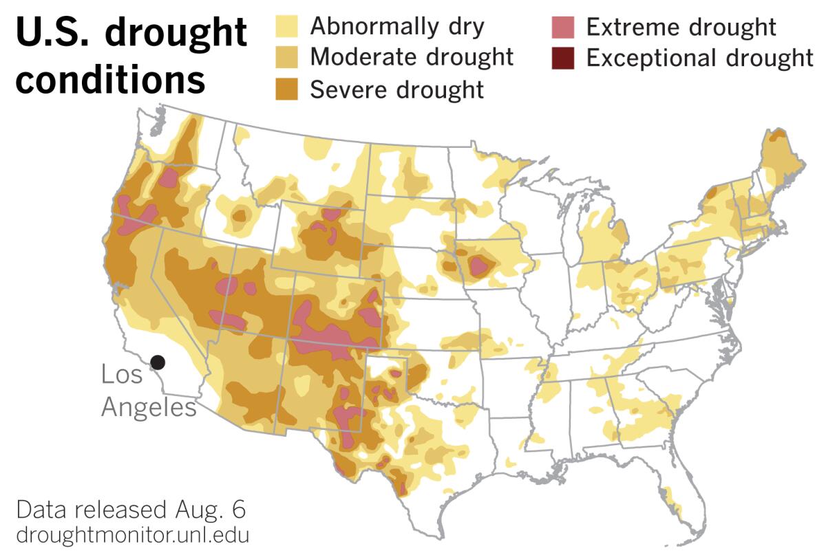
Hot and dry conditions pushed portions of Arizona, southern Nevada and Southern California either into drought or further into drought, data from the U.S. Drought monitor show.
The portion of California deemed abnormally dry grew by almost 7%, mainly in eastern San Bernardino County. Large portions of Arizona and parts of southern Nevada slipped from abnormally dry into moderate drought, and severe drought expanded in southern Arizona.
Northern California remained about the same, which is to say either in moderate or severe drought, with an area of extreme drought mostly confined to Siskiyou County up on the Oregon border.
The North American Monsoon, which provides about half of the annual rainfall in parts of the Southwest, has been a ŌĆ£nonsoonŌĆØ this year.
ŌĆ£We thought last yearŌĆÖs monsoon season was rough,ŌĆØ said Rob Howlett of the National Weather Service office in Tucson, ŌĆ£but this yearŌĆÖs is worse.ŌĆØ
This is consequential for people living in Southern California because the Four Corners region of the Southwest is part of the Colorado River watershed, and the Colorado River is a major source of water for Los Angeles and Southern California.
July and early August are the peak of the monsoon season. Normal rainfall for July in Tucson is 2.25 inches. In 2019, Tucson got 1.07 inches in July, but this year it got only 0.46 inches. Last yearŌĆÖs monsoon season total was about an inch less than normal. So far, this year is even drier.
The National Oceanic and Atmospheric AdministrationŌĆÖs outlook for August is bleak. It favors below-average precipitation in Arizona and the Four Corners region.
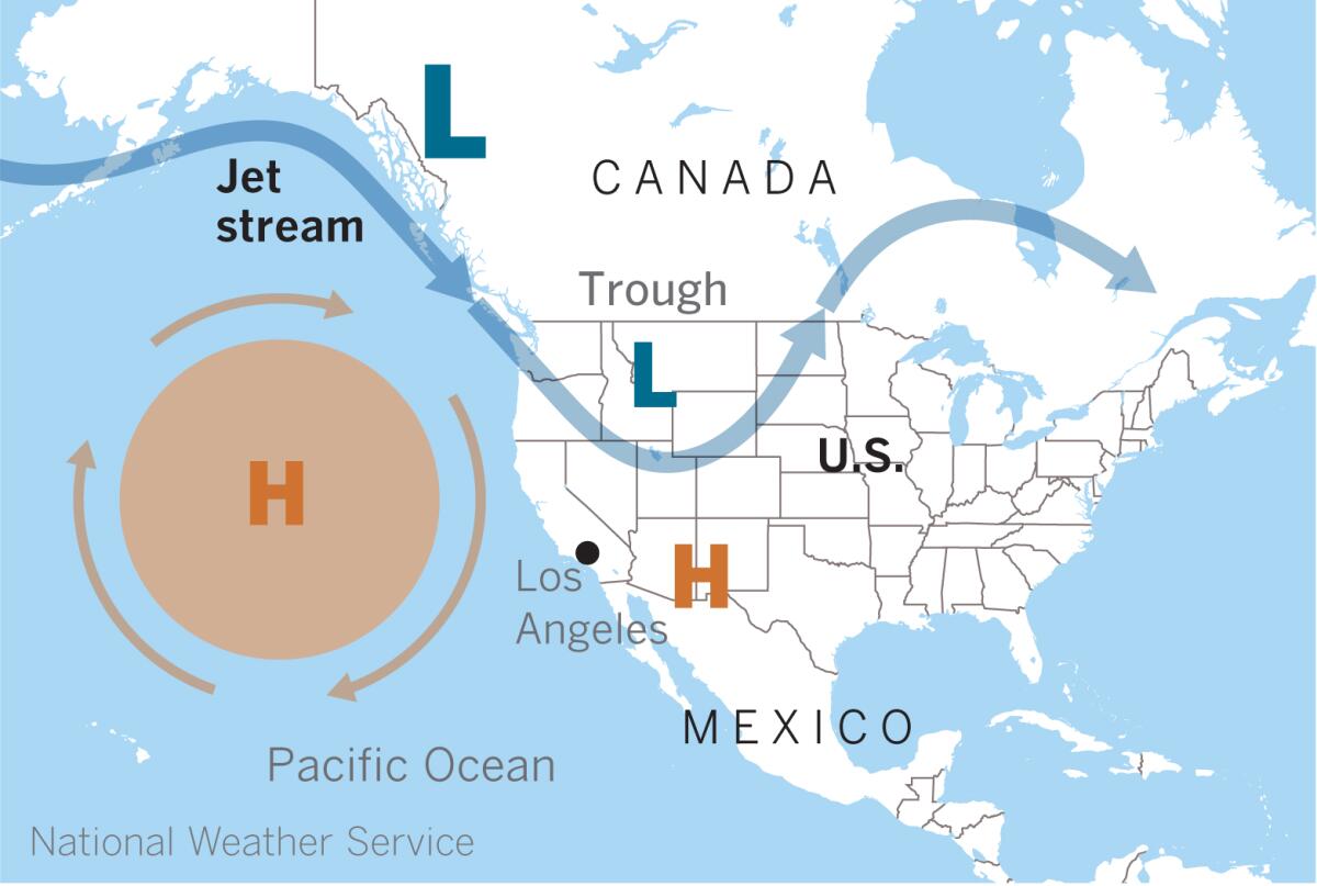
During the summer, a strong ridge of high pressure over the northern Pacific has been forcing the jet stream farther inland over the Intermountain West, Howlett explained. ŌĆ£This has a cascading effect, because it then forces our monsoon ridge farther south.ŌĆØ

Under normal summer conditions, a high-pressure system develops over the Mexican Plateau and shifts northward into the U.S. southern Rockies or southern Plains by early July. Mid- and upper-level moisture is transported into Arizona and the Southwest from the Gulf of California and the Gulf of Mexico.
But many times this summer, said Howlett, the high has been centered directly over Arizona, producing excessive heat. July was the hottest month on record for Tucson, he said.
July in Tucson was also the 10th driest on record, according to the National Weather Service, with the second-latest start of the monsoon season.
The location of the high-pressure ridge suppressed thunderstorm development. ŌĆ£We really depend on that ridge being farther north so we can tap into the southeast and east winds,ŌĆØ Howlett said.
The jet streamŌĆÖs position in June and July fed dry westerly flow across Southern California and into the Southwest, keeping tropical moisture to the south and east.
NOAAŌĆÖs three-month outlook in the Southwest calls for equal chances of above- or below-normal precipitation. That could mean an active September and October, which usually is linked to tropical moisture sources, Howlett points out. ŌĆ£WeŌĆÖll see how that shakes out.ŌĆØ
ŌĆ£The wild card as we move into late August and September is the latest prediction of an extremely active Atlantic hurricane season,ŌĆØ said climatologist Bill Patzert.
The updated forecast released by Colorado State University on Aug. 5 calls for 24 named storms ŌĆö twice the average ŌĆö of which 12 will become hurricanes. Five are expected to be major hurricanes.
ŌĆ£Historically, 48% of these hurricanes will make landfall along the Gulf Coast. If any of these hurricanes come ashore in south Texas or northern Mexico, they could potentially give the Southwest monsoon season a late soaking,ŌĆØ said Patzert.
More to Read
Sign up for Essential California
The most important California stories and recommendations in your inbox every morning.
You may occasionally receive promotional content from the Los Angeles Times.


