Bridge poses a tight squeeze for cargo ships
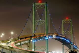
Before dawn, in the waters of Long Beach’s Back Channel, three tugboats struggle to control the container ship MSC Texas as it approaches the Gerald Desmond Bridge.
What happens next represents one of the greatest tests of skill and nerve at the two seaports that form the nation’s busiest shipping complex.
The bridge is so low that the ship -- one-fifth of a mile long but dwarfed by newer vessels -- can pass below only under optimal conditions. Three pilots are onboard to monitor the ship’s position at all times; it squeezes underneath the bridge’s deck with just a few feet to spare.
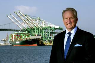
“This ranks No. 1 in difficulty in terms of what we do,” said Capt. Vic Shisler, a harbor pilot who has guided ships to docks for 43 years. “The obstructions above, below and between the bridge towers leave a very low margin for error.”
Port of Long Beach officials want to tear down the bridge and replace it with one that is taller and wider to accommodate the biggest cargo ships, which are nearly twice the size of the Texas.
But officials, who last week released a revised draft environmental impact report for public comment, say that the low clearance over cargo ships isn’t even the most compelling argument for a new bridge.
Another is the bridge’s strategic location as a primary link between Terminal Island cargo facilities and Long Beach.
Officials at the Los Angeles and Long Beach ports estimate that the bridge carries 15% of all the nation’s cargo that moves by sea. It has five traffic lanes, a walkway on one side, and no shoulders or emergency lanes. Any accident involving vehicles that can’t be driven off can shut down one side or the other, diverting traffic onto adjacent streets that are easily jammed.
“I’m not sure there’s another bridge anywhere in the country that has to handle that kind of traffic burden. It really has become the bridge to everywhere,” said Richard D. Steinke, executive director of the Port of Long Beach. “It can’t carry the amount of cargo it needs to, and we need to position ourselves for the future.”
Then there’s the safety problem.
The 42-year-old bridge was designed to handle relatively light traffic for the shipyards and dwindling fishing industries that dominated Terminal Island in the 1960s.
But the constant pounding of heavy trucks and commuter traffic has stressed the bridge to the point where its Caltrans structural “sufficiency” rating is only 43 out of a possible 100 points as of August 2007.
The bridge wears nylon mesh “diapers” to catch chunks of concrete falling from its deck.
Inland Empire economist John Husing, who studies goods movement in the region and served on the California Infrastructure Advisory Committee, puts it more bluntly.
“The infrastructure to move goods out of the harbor is essential to the economic base of Southern California,” he said. “To have a decaying bridge in the middle of it is unacceptable. It’s old. It’s not high enough, and it’s falling apart.”
Some of those calling for funding of the new bridge and marshaling support for it have no direct responsibility for the ports of Los Angeles and Long Beach. Neither port is in the district of Rep. Laura Richardson (D-Long Beach), but enough of her constituents work at them that the congresswoman has used her membership on the House Committee on Transportation and Infrastructure to push for more than $375 million in federal funds for the project.
Richardson said she is concerned about the possibility of an incident similar to the 2007 bridge collapse in Minnesota in which 13 people died, although she acknowledged that a design flaw was a strong contributor to that disaster.
“A disaster on this bridge would have an impact all across the U.S.,” she said.
Some neighbors oppose any effort to replace the bridge with a structure that would become an even busier freight corridor.
“We don’t support it if it’s going to be another example of commandeering a public roadway to become a freight transportation route,” said Jesse Marquez of Wilmington, founder of a citizen advocacy group called Coalition for a Safe Environment. Marquez said that plans to speed cargo from the ports to the rest of the nation are too often made at the expense of the well-being of nearby residents.
“Wal-Mart and the other retailers aren’t going to be paying for that new bridge,” he said. “The public will wind up paying for it when the money should be spent on moving cargo with new technologies that don’t add to pollution and emissions.”
For years, there was no bridge at all, just a ferry. In 1944, the U.S. Navy erected a pontoon bridge that was supposed to be used for only six months. Instead, the pontoon bridge was in place for 24 years, sometimes with disastrous results. Some motorists, approaching it too fast, became airborne, landed in the water and drowned in their cars.
In 1968, the Gerald Desmond Bridge was built, but planners expected only modest traffic -- mostly people going to and from the Long Beach Naval Shipyard on Terminal Island. But by the 1990s, the shipyards were closed and the fishing industry had all but disappeared. Long Beach then emerged as the nation’s busiest container port, until 2001, when it was eclipsed by the neighboring port of Los Angeles.
Now the bridge handles 18 million vehicle trips a year, Port of Long Beach officials say.
The new bridge would add a sixth traffic lane and two emergency lanes and would clear the water by 200 feet, an increase from 165. That would be high enough, port officials say, to handle the biggest cargo ships afloat.
Then again, that’s what they said about the old bridge, in 1968.
More to Read
Sign up for Essential California
The most important California stories and recommendations in your inbox every morning.
You may occasionally receive promotional content from the Los Angeles Times.


