Tapping a Reservoir of Good Scenery
You can’t practice your backstroke in it, but it’s mighty pretty. Jameson Reservoir holds part of Montecito’s water supply and is off-limits to swimmers, but its oasis-like setting, with its backdrop of handsome sandstone rocks, is attractive to hikers.
The trail is the old Santa Ynez Fire Road, constructed by the Civilian Conservation Corps to encourage recreational use of this remote part of Los Padres National Forest. This dirt road was once a major route over the mountains from Santa Barbara to Ojai.
It parallels the upper reaches of the Santa Ynez River and travels to the reservoir and to an intersection with Franklin Trail, which leads to Alder Canyon Camp. The camp isn’t much, but it has a fairly dependable water supply in Alder Creek.
The trek to Jameson Reservoir and Alder Camp is sufficient for most hikers, but hikers may continue up Juncal Trail (Santa Ynez Fire Road) to upper Santa Ynez Camp and then to Murietta Divide. From the divide, on the boundary between Santa Barbara and Ventura counties, the intrepid hiker could descend to Murietta Canyon and Matilija Canyon near Ojai.
The wild back country around the headwaters of the Santa Ynez River is all the more impressive because it’s scarcely 10 as-the-condor-flies miles from downtown Santa Barbara. As we’re not fast-flying condors, we need to drive a long, circuitous route to get to Juncal Camp, starting point for this hike. Allow 90 minutes for the bumpy but scenic drive from Santa Barbara to the trail head.
Directions to trail head: From U.S. 101 in Santa Barbara, exit on Mission Street and head east to Laguna Street. Turn left (north) and wind past the Santa Barbara Mission. Turn sharply right on Mountain Drive and follow it to a three-way junction north of Sheffield Reservoir. Take the middle byway, Gibraltar Road, and drive seven winding miles to Camino Cielo Road. Turn right and follow the road six miles to Romero Saddle, then descend 4.6 miles on bumpy dirt road to Juncal Camp on the north bank of the Santa Ynez River. The trail (Santa Ynez Fire Road) begins east of camp at a locked gate.
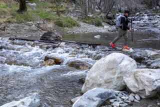
The hike: Cross the Santa Ynez River at the ford just beyond the locked gate and follow the dirt road along the north side of the river. En route are some handsome oak-dotted meadows bursting with bush lupine.
The upper Santa Ynez Valley is rather wide and the river often takes more than one course through it. Several side trails lead down to the river. The flow of the Santa Ynez River varies with the season and releases from the reservoir.
A bit more than a mile out, you’ll wade across the river again at a distinct, cement-bottomed ford. As you approach the reservoir, you’ll head downward, then follow the road along the Jameson’s edge. A half-mile past the dam, you’ll spot a water flume channeling Alder Creek into the river and reach a signed junction with a road leading right. Join Franklin Trail, crossing a meadow and heading up-canyon along Alder Creek past cascades and pools. The creek-side trail, lined with alders, leads a short mile to Alder Camp, little more than fire pits and flat spots by the creek.
From its junction with Franklin Trail, Santa Ynez Fire Road continues along Jameson Reservoir. Above the reservoir is Billiard Flats, a rolling set of meadows.
Past the east end of the reservoir, Santa Ynez Canyon narrows. The fire road crosses the creek again, then begins a stiff climb to Murietta Divide. All-but-abandoned Upper Santa Ynez Camp, another relic from the 1930s, is perched below the divide.
McKinney’s book “Day Hiker’s Guide to Southern California” is available through The Times for $16.45 (including tax, shipping and handling) by calling (800) 246-4042.
Where: Jameson Reservoir, Los Padres National Forest
Distance: From Juncal Camp to Jameson Reservoir is six miles round trip with 400-foot evaluation gain; to Alder Camp is 9 miles round trip with 800 gain; to Murietta Hot Springs is 12 miles round trip with 1,600-foot gain.
Terrain: Oak-dotted meadows, rolling country of the upper Santa Ynez River.
Highlights: Out of the way walk on historic “highway.”
Precautions: Take along a Los Padres National Forest map. The Forest Service requires that your vehicle display an Adventure Pass.
For more information: Los Padres National Forest, 6144 Calle Real, Goleta, CA 93117; tel. (805) 683-6711.
More to Read
Sign up for The Wild
We’ll help you find the best places to hike, bike and run, as well as the perfect silent spots for meditation and yoga.
You may occasionally receive promotional content from the Los Angeles Times.


