Farmers Till Technology to Boost Yields
WASHINGTON â A generation or two ago, a farmer like Gary Wagner might have consulted his almanac and eyed the phase of the moon before planting his Minnesota wheat crop. Today, Wagner uses infrared satellite images and a laptop computer.
A satellite photo shows Wagner the progress of his wheat crop. He plugs the data into a computer program that combines it with other information such as historic yields, soil moisture and the slope of his land.
A global positioning system receiver on his tractor uses other satellites to determine his precise location in the field.
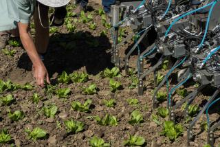
This emerging technology, known collectively as precision agriculture, uses satellites, computers, lasers, ground-based monitors and yield counters to bring the latest science to the ancient art of farming.
As he drives the tractor across his 4,000-acre Red River Valley farm, Wagnerâs computerized system automatically spreads fertilizer in the exact amounts needed for the crop--more in some places, less in others.
âWeâre probably using the same amounts, but weâre applying fertilizer where itâs needed--not just a blanket application,â Wagner said.
He gets better yields out of his wheat, barley, soybeans and sugar beets. The environment is protected because less fertilizer is wasted and winds up leaching into wells and rivers. And, ultimately, Wagnerâs profits go up.
Over in Wyomingâs Bighorn Mountains, satellites analyze light reflected from Earth to help rancher Jim Foreman determine when rangeland grass contains the most nutrients for his cattle. If the grass is more nutritious, Foreman doesnât have to buy as much hay for winter.
âIt helps in moving the cattle around. The better grasses, the better weight gain,â Foreman said. âThe better condition theyâre in, the better they can withstand weather or disease.â
Although agriculture has used aerial and satellite photography for years, for the most part its large-scale level of detail has only been useful for big farmers in limited ways. Farmers now use data from 24 satellites that were originally developed for the Pentagon.
Next year, NASA will launch two satellites--and private firms are planning more--that can analyze parcels of land down to about 1 yard in length.
âYouâre going to get a lot more information,â said Alex Tuyahov, applications research manager for NASAâs Mission to Planet Earth. âIâm certain itâs going to have much wider applicability.â
Right now, farmers are only scratching the surface of the new technology. Only about 10% of Americaâs 1.9 million farmers have computers, and high cost of investing in new equipment is a major impediment.
A National Research Council study found that raw satellite imagery can cost $80,000 a season but that, once processed for specific fields, it can be sold for about $8 an acre. Corn fertilizers, in comparison, cost an average of $46 an acre.
âThereâs wonderful technology out there nowadays, but thereâs a little bit of a question how it will play out as a consumer good,â said Lee Johnson, a scientist based at NASAâs Ames Research Center in San Jose.
âRight now, farmers feel thereâs a bit of information overload,â said George Seielstad, associate dean at the University of North Dakotaâs Center for Aerospace Sciences. âThe next step is to integrate all this information so a farmer can just glance at something and know what to do.â
In Californiaâs wine-rich Napa Valley, NASA has been working with Robert Mondavi Vineyards and a new technology company called Terra Spase on practical ways to use digital aerial photography that can detect various bands of the light spectrum as reflected by plants from 14,000 feet up.
In one project known as CRUSH, these light bands are analyzed to detect the vigor of chardonnay and pinot noir vines through the thickness of the leaf canopy. The canopyâs health helps Mondavi evaluate whether the grapes are mature enough to pick and what their acid levels will be.
In the old days, when there were more farmers and smaller farms, it was easier to know each piece of ground intimately. Farmers kept knowledge in their heads about what areas needed more irrigation, where to cut back on fertilizer and the like.
Wagner, the Minnesota farmer, said that when his father died, it took 15 years to figure out some of those things on his large spread. With the new technology, he said, it is available at oneâs fingertips.
âThe next generation isnât going to have to start at ground zero again,â Wagner said. âIt is difficult. It is expensive. On the other hand, I compare it a lot to a college education. The more you understand of your occupation, the better job you can do.â
More to Read
Inside the business of entertainment
The Wide Shot brings you news, analysis and insights on everything from streaming wars to production â and what it all means for the future.
You may occasionally receive promotional content from the Los Angeles Times.


