COLUMN ONE : Where in the World Are You : The Pentagon’s satellite tracking system can pinpoint a ship at sea within 15 feet. Scientists can tell how high mountains rise and which way cities move after major quakes.
Andrea Donnellan kneels on the barren crest of Oat Mountain and, with her Powerbook computer coupled to a tiny satellite receiver, pinpoints the shards of Southern California’s broken landscape with an unsettling accuracy.
It is as she suspected.
The 3,477-foot-tall mountain, heaving upward since the moment of the 6.6 Northridge earthquake last month, has grown another inch since she last checked.
“This is mountain-building in progress,” she said.
In all, Oat Mountain is about 14 inches taller--exactly 36 centimeters--as a result of the earthquake. The mountain, which stands like a garden wall between the San Fernando and Santa Clarita valleys, also moved nearly nine inches to the northwest.
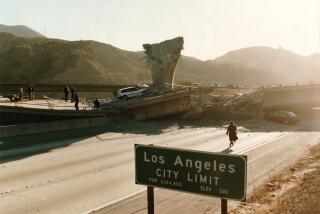
Northridge itself was distorted like a Salvador Dali watch--with a 38-square-mile oval of ground on which it rests now bulging a foot higher and skewed to the southeast.
It may be time to start redrawing the property lines.
When it comes to surveying the Santa Susana Mountains or the San Fernando Valley, geophysicists such as Donnellan and her colleagues can calculate the effects of the Earth’s sudden spasms to the nearest millimeter through a $12-billion Defense Department satellite network called the Global Positioning System.
The Pentagon developed the satellite navigation system, which became fully operational in July, to maneuver troops, position its ships and target its missiles.
But the same revolution in measuring technology that enables military planners to aim their missiles with unprecedented precision and Desert Storm Stealth pilots to find Baghdad in the dark also allows Donnellan at the Jet Propulsion Laboratory and other geologists to track the shifting of the Earth’s crust as tectonic plates jostle like icebergs in a floe.
Space geodesy--the ability to survey the Earth from orbit--has given geologists new eyes, transforming their vision of Southern California.
By using the satellites to monitor the San Fernando Valley, Donnellan and her colleagues developed an unusually comprehensive profile of the strains building up in there. That led them to raise the possibility of a major earthquake in the area in a scientific paper published two months before the Northridge temblor. They could not say when such a quake would hit.
“We came up with an estimate of a 6.4 earthquake, which is pretty close to what actually happened,” she said. “GPS is a very elegant tool to use.”
Indeed, the satellite system is transforming nearly every endeavor in which location matters.
Airlines are experimenting with the system to eliminate delays and save fuel by identifying more direct routes for passenger jets. In Tokyo, tour bus operators are using GPS receivers to trigger recorded lectures for sightseers when their buses pass a notable landmark, while paleontologists are using portable receivers to navigate the trackless Gobi Desert.
Weekend campers use it to keep from losing their way in wilderness--at least those who can afford to pack the $795 hand-held receivers in their gear. Naturalists in Montana monitor elk by tagging them with GPS collars. Foresters even use GPS to inventory trees.
It is perhaps no surprise then that many experts call the system the most significant development in space technology since the communications satellite.
“It is the first precise, inexpensive measuring system,” said geophysicist Duncan C. Agnew at the Scripps Institution of Oceanography and UC San Diego. “You can make precise measurements over thousands of miles. We are all amazed by it,” he said.
The satellites are a high-tech variant of a centuries-old celestial navigation technique.
Circling the Earth every 20 hours, 24 GPS satellites constantly transmit their position, identity and the time the signal was broadcast. The satellite clocks are synchronized with each other and with a master atomic clock on the ground.
Anyone with a GPS receiver can pick up the satellite signal, compare the time it was sent with the time it was received and, by calculating the difference, determine how far away the satellite is. By tuning in to at least three GPS satellites, the receiver quickly can pinpoint its position anywhere in the world.
“If you know where the satellites are, you know where you are,” Donnellan said. “When you can have three or more satellites, you can place yourself pretty accurately. It is like drawing intersecting circles.”
For the Defense Department, which spent 20 years developing it, the system allows any ship, plane, submarine or soldier with a GPS satellite receiver to locate itself to within 15 feet anywhere in the world. Because the signals are beamed from space, they effectively are impossible to jam.
The Pentagon, concerned that someone might turn the technology against its inventors, guards its navigation system by reserving the most precise GPS signals for itself. The transmissions that would enable someone to receive the most exact positioning information are encrypted. Others contain intentional “spoofing” errors that only the Pentagon can detect and filter out.
The Pentagon does make five powerful signals from GPS satellites accessible to civilian receivers. For these non-military users, that is sufficient to locate themselves to within 100 yards.
But geodetic experts--as scientists who specialize in precise Earth measurements are called--are wringing much greater accuracy from those signals, enough to make some Pentagon planners uneasy.
To hone their calculations, specialists such as Donnellan and Agnew combine the resources of NASA’s 45 global tracking sites, conventional surveying and sophisticated computer processing to determine the precise position. The special $35,000 receivers they use, developed by JPL, can extract some useful information from the Pentagon’s coded signals.
The result is that they can improve each geodetic survey measurement from 100 yards to one that is accurate within an inch.
That should pose no threat to anybody, the geologists hasten to explain, because it is not the sort of thing one could do under battlefield fire.
Before the advent of GPS, the most advanced geodetic technique used distant quasars as measuring sticks, a method that required the use of large radio telescopes--not the sort of thing a field geologist could tote up a mountainside.
“GPS is definitely helpful because it tells you what the broad picture is quickly,” said Tousson R. Toppozada, a seismologist with the state Division of Mines and Geology. “GPS will tell you the mountains went up with respect to the valley. Without GPS, we would have to wait months to find out.”
To geologists, the satellite measurements reveal a world in which the Earth creeps at the speed that fingernails grow.
“If you are patient, you can see very small motions . . . five millimeters over five years,” Agnew said.
San Clemente Island hurtles north past San Diego at a rate of one-fifth of an inch every year, according to Agnew’s recent satellite survey. Catalina rumbles toward Palos Verdes at a speed of one-tenth of an inch each year. The entire Santa Barbara Channel is snapping shut at about three-tenths of an inch every year, his measurements show.
Not all the motion revealed by the GPS satellites is natural.
A recent satellite survey of the Tucson Basin in Arizona revealed that the 1,000-square-mile area is sinking about two inches a year because people have pumped out so much ground water that the aquifer is collapsing.
Geologists are especially intrigued with the way the satellite measurements reveal how the ground shifts as a result of an earthquake.
“It has made a huge difference to us,” said geodetic specialist Ken Hudnut at the U.S. Geological Survey.
Almost immediately after last month’s big quake, Hudnut and his colleagues scrambled to set out 16 portable GPS receivers around the area so they could measure how far the Earth had shifted at the 100 benchmarks they had surveyed earlier.
Each receiver, not much larger than a portable videotape recorder, is housed in an unobtrusive steel lockbox and powered by a pair of car batteries that have to be recharged about every 10 days.
Yehuda Bock at the Institute of Geophysics and Planetary Sciences at the Scripps Institution of Oceanography, who works closely with Hudnut and Donnellan, already had a permanent network of 10 GPS receiving stations in place, scattered from San Diego in the south to Vandenberg Air Force Base in the north. Those receivers update their position every 30 seconds and report their data daily. Any variation caused by the shifting crust or a sudden quake is recorded.
The instant the Northridge quake hit, the Los Angeles Basin--stretching from Palos Verdes to Pasadena--shrank by half an inch, according to Bock’s GPS measurements.
In the past, experts were not able to capture enough information about an earthquake fast enough to understand just how such an upheaval unfolds. It could take months to painstakingly resurvey each benchmark.
By combining all their data, Donnellan, Hudnut and Bock were able to take a “snapshot” of the Earth in flux, from precise measurements of the rising Santa Susanas to the fractional shifts in the positions of a dozen communities around the region.
This week, Bock set up another GPS receiver in Chatsworth. In six months, he hopes to have five more installed around Los Angeles County.
Donnellan, Hudnut and Bock are casting a net to snare an earthquake. As they wire Southern California into a GPS network, the scientists hope they may catch a glimpse of the subtle signs that may precede a temblor, giving them the rudimentary tools to one day predict when a major quake might occur.
“We are looking to see if there are any signals that will give us some clues to unraveling earthquakes--how they happen, what happens during one and the patterns that may lead up to it,” Bock said.
Extrapolating from ground movements during the Northridge quake, they could reconstruct what happened at the focal point of the temblor more than 11 miles below the Earth’s surface.
There, they believe, a patch of rock about 32 square miles slipped about 18 feet along the angled face of the deeply buried thrust fault. The energy unleashed by the movement was enough to claim at least 57 lives and cause $30 billion damage to the region above.
“It was a little bit deeper than some of our earthquakes have been,” Hudnut said. “The displacement of the fault gets muted by the overlying rock. That damped the ground movement for this earthquake.”
In other words, it could have been worse.
In the weeks after the Northridge quake, the GPS stations showed that the Earth continued to deform. One brutal aftershock kicked Oat Mountain half an inch backward.
As they continue to sift through the measurements gathered from the quake, scientists hope to detect some pattern that may presage a major temblor.
“We are examining the Northridge data for possible variations in the contraction rate,” Bock said. “We are excited about the prospects, but right now we can’t say if there is anything for sure.”
A Moving Experience
Here is how far some communities were moved by the Northridge quake according to Global Positioning System measurements:
1) Oat Mountain: up 14.8 inches and moved northwest 8.4 inches
2) Fillmore: moved 2 inches west
3) Castaic: dropped 3.5 inches and moved 4.3 inches southwest
4) Santa Paula: west about 2 inches
5) Moorpark: west about 2 inches
6) Point Dume: north 1.5 inches
7) Glendale: moved east 0.5 inches and up 2 inches
8) Topanga Canyon at Mulholland: moved north 3 inches and up 1.3 inches
9) Van Norman Reservoir at intersection of I-5 and 405: moved east 7 inches and up 8 inches
Source: Jet Propulsion Laboratory, U.S. Geological Survey
More to Read
Sign up for Essential California
The most important California stories and recommendations in your inbox every morning.
You may occasionally receive promotional content from the Los Angeles Times.


