Pine Mountain Vistas of Peaks and Valleys
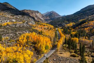
The invigorating scent of pine, great views and a dramatic ridgetop trail are some of the highlights of a hike atop Pine Mountain. The mountain, which straddles the Mt. Pinos and Ojai ranger districts in Los Padres National Forest, is composed of several 7,000-foot-plus peaks, each offering a different back-country panorama.
Wilderness-bound travelers have always had a difficult task in deciding what to call the rugged mountain terrain arranged in a very wide semicircle around Ojai and Santa Barbara. The padres left behind many names, but none of them took. Geologists aren’t much help either. They call the land the “Transverse Ranges Geomorphic Province.” Unlike other areas of Southern California, there isn’t a single dominant mountain range, but a number of smaller ones with names such as Sierra Madre and Santa Ynez, Pine and Topatopa.
Whatever this land of great gorges, sandstone cliffs and wide blue sky is called, it’s guaranteed to please.
Reyes Peak and Reyes Peak Trail, as well as a nearby camp and creek, are named for an early California family that began ranching in the Cuyama Valley in the 1850s. One descendant, Jacinto Reyes, was among the first forest rangers of the Santa Barbara (later Los Padres) National Forest.
For most of its length, Reyes Peak Trail stays atop, or contours just below, the ridge top connecting Reyes to its sister peaks. The well-constructed footpath is shaded the whole way by white fir, Jeffrey, Ponderosa and sugar pines. Inspiring views are offered from uninspiringly named Peaks 7,091, 7,114 and 7,416, as well as from the saddles between the summits.
Directions to the trailhead: From U.S. 101 in Ventura, exit on California 33 and head north 47 miles (32 miles past Ojai) to the signed turnoff for Pine Mountain Recreation Area. Follow the narrow paved road past some campgrounds. After six miles, the paved surface ends, and you’ll continue east one more mile on a dirt road (suitable for most passenger cars) to road’s end, where there’s a modest amount of parking.
The hike: Follow the dirt road (closed to vehicles beyond the trailhead) about 150 yards. As the road curves southeast, join the unsigned eastbound trail that begins on the east side of the road. The trail descends slightly and soon passes below the pine- and boulder-covered summit of Reyes Peak (7,500 feet), high point of the Pine Mountain massif. Pine and fir shade the trail, which alternately follows the ridge line and contours just below it.
You’ll look down to the northwest at the farms and ranches of Cuyama Valley, and beyond to the stark sandstone Cuyama Badlands.
There are occasional pine-framed views of Mt. Pinos (elevation 8,831 feet), highest peak in Los Padres National Forest. From the ridgetop, you’ll be able to peer southwest down into the Sespe River gorge.
After about 1 3/4 miles of travel, you’ll be treated to a view of the canyon cut by Potrero John Creek. The eroded cliffs at the head of the canyon recall Utah’s Bryce Canyon National Park or Cedar Breaks National Monument.
Reyes Peak Trail continues east through pine and fir forests. After two more miles of travel, you’ll spot an orange, triangular-shaped, metal forest-service marker.
Drop into and switchback out of a hollow and arrive at signed Haddock Peak. The peak offers good views to the south and west of the Ojai backcountry.
From the peak, the trail descends in earnest. Almost 2 miles of travel brings you to Haddock (pronounced hay-dock) Trail Camp, located on the banks of Piedra Blanca Creek.
Reyes Peak Trail
Reyes Peak Roadhead
to Potrero John Overlook :
3 1/2 miles round trip;
300-foot elevation gain .
Reyes Peak Roadhead
to Haddock Peak :
7 1/2 miles round trip;
600-foot elevation gain .
Reyes Peak Roadhead
to Haddock Trail Camp :
11 miles round trip;
800-foot elevation gain .
More to Read
Sign up for The Wild
We’ll help you find the best places to hike, bike and run, as well as the perfect silent spots for meditation and yoga.
You may occasionally receive promotional content from the Los Angeles Times.


