East Coast Worries, Waits as Hurricane Bears Down : Storm has Winds Up to 150 M.P.H.
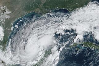
MIAMI ŌĆö Hurricane Gloria, packing 150-m.p.h. winds and churning up 25-foot seas, howled toward the East Coast today, threatening an area from the Carolinas to Maine with one of the worst lashings of the century.
Officials urged evacuation of parts of North CarolinaŌĆÖs Outer Banks by Thursday morning.
The National Hurricane Center in Miami issued a hurricane watch for the Outer Banks from Cape Lookout north to the Virginia border.
Coastal residents from South Carolina to Maine were warned to ŌĆ£be ready for quick action.ŌĆØ
ŌĆ£This is a dangerous hurricane,ŌĆØ an advisory warned. ŌĆ£Interests along the East Coast, particularly from the Carolinas to New England, should closely monitor the progress of Gloria.ŌĆØ
Catastrophic Potential
One a scale of 1 to 5, forecasters classified Gloria a ŌĆ£borderlineŌĆØ Category 5 hurricane, the only one ever recorded over the open Atlantic Ocean and one of the three most powerful storms of the century. A Category 5 hurricane is capable of catastrophic damage.
At midday, Gloria was centered about 600 miles south-southeast of Cape Hatteras, N.C.
It was moving northwest at nearly 15 m.p.h. and was expected to gradually turn more toward the north and pick up speed, making landfall within two days at most. The Bahamian government discontinued all warnings for the Bahamas as the threat to that area dissipated.
The National Weather Service at Cape Hatteras advised residents of the Outer Banks, a string of barrier islands dotted with fishing and resort villages, to prepare for strong winds and high tides that could cut off roads to the mainland.
Evacuation Requested
ŌĆ£State officials have asked for the evacuation of Ocracoke and Portsmouth islands. Other evacuations may be needed later,ŌĆØ the advisory said. ŌĆ£All preparations to protect property and equipment should be rushed to completion by sunset today.ŌĆØ
Ships from the Charleston, S.C., Navy Base were sent to sea today to ride out the storm.
ŌĆ£You are again reminded this is an extremely dangerous hurricane,ŌĆØ the advisory said. ŌĆ£The decision to leave must be acted on no later than sunrise Thursday.ŌĆØ
Forecaster Mark Zimmer said if the hurricane turns farther to the north as expected, it could miss North Carolina and hit farther north, but forecasting is seldom that precise.
Peril Extends to Maine
ŌĆ£If it did exactly what we expect it to, it would pass very close to the Outer Banks and continue north and northeast,ŌĆØ Zimmer said. ŌĆ£The danger extends all the way from Myrtle Beach, South Carolina, all the way up to the coast of Maine. The highest probabilities now are 20% for the Outer Banks.ŌĆØ
ŌĆ£The only Category 5 storms to hit the United States this century were the 1935 hurricane in the Florida Keys and Camille in 1969,ŌĆØ Zimmer said.
ŌĆ£What we want to emphasize about Gloria is that whether it is a 4 or a 5 it is a very dangerous hurricane. We donŌĆÖt want to give any indication that it is weakening. It will fluctuate, pulsate. The pressure may go up and down and the winds may vary from 145 to 155 miles per hour,ŌĆØ Zimmer said.
ŌĆ£But if you get hit with winds of 145 miles per hour or 155 miles per hour, itŌĆÖs pretty extreme either way,ŌĆØ he said.
Gloria formed as a tropical depression near Cape Verde, Africa, and swept across the Atlantic for nearly five days before reaching hurricane strength Sunday.
Typically, Cape Verde storms are the most powerful and dangerous and pose the greatest threat in September and October.
More to Read
Sign up for Essential California
The most important California stories and recommendations in your inbox every morning.
You may occasionally receive promotional content from the Los Angeles Times.


